Report says St. Kitts and Nevis has lost 35 square miles of land since 1961. But did it account for Anguilla?
Get our headlines on WHATSAPP: 1) Save +1 (869) 665-9125 to your contact list. 2) Send a WhatsApp message to that number so we can add you 3) Send your news, photos/videos to times.caribbean@gmail.com

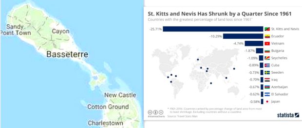
Basseterre, St. Kitts, September 9, 2018 – St. Kitts and Nevis has shrunk by a quarter over the past 56 years.
“Since 1961, the twin island country of St. Kitts and Nevis has shrunken by more than 25 percent,” said Statista.com, an online portal of statistics which claims immediate access to over one million statistic and facts.
“This dramatic land loss can be attributed to regular erosion and natural disasters, notably Hurricane Luis, Hurricane Georges and Hurricane Lenny,” said the post authored by Niall McCarthy.
“Between 1961 and 2017, the Caribbean island nation of St Kitts and Nevis lost more than a quarter of its land area – the most of any country in the world – primarily due to rising sea levels. The dual-island country is relatively exposed geographically, making it more heavily impacted by extreme weather events like hurricanes and extreme storms, such as Hurricanes Luis (1995), Georges (1998), and Lenny (1999), which have battered the nation in recent years,” said Madison Dapcevich in another post on London-based IFLScience Store.
“In all, St Kitts and Nevis lost about 90 square kilometers (35 square miles) of land. Ecuador saw the next largest decrease, losing more than 10 percent of its area or a total of nearly 28,500 square kilometers (11,000 square miles). Vietnam and Bulgaria, which lost 4.74 percent and 1.87 percent of their land respectively, were closely followed by the island nations of the Seychelles and Cuba,” said Dapcevich.
Statista and IFLScience gave no data of the square miles in 1961 and at the end of 2017.
Dapcevich noted that around the world, coastal communities may soon find themselves struggling to keep their heads above water.
“Data compiled by the World Bank shows the 37 countries that have lost the most land over the last half a century and, while some losses are more dramatic than others, nearly every coastal country in the world could see a loss at the turn of the century.
When these extreme weather events hit, winds push sand from the beach system and deposit it offshore onto large sandbars, causing the beaches to become narrower and lower in elevation, according to the US Geological Survey. Not only does this displacement impact economies that rely on expansive white sand beaches for tourism, but beach erosion also threatens coastal properties and infrastructures like roads and buildings,” said the post.
However there might be a very reasonable explanation and it has nothing to do with inatr change. Mrs Jacqueline Armony gave this very plausible explanation as to the 35 sq miles difference from 1961 to 2018.
Mrs Armony state “Because the starting date of study was in 1961, it has been suggested that these figures do not take into consideration the ‘loss’ of Anguilla that is believed to have been included in the stats. Yes we are losing land due to sea level rise but not at the rate indicated in this article. I think this is an important error on the part of the statisticians if this is so.”
Leave a comment
You must be logged in to post a comment.